

Flights
If you’re coming from New York, New Jersey, Connecticut, Chicago,
Minneapolis, Southern California or Japan, you should plan to fly into
either Oakland Airport or San Francisco Airport, and we suggest you fly
in on Thursday, December 30th (if not sooner!). We think Jet
Blue is the best airline out there, so if you’re coming from
the East Coast, we’d suggest taking Jet Blue from JFK to OAK.
Driving
You’re going to have to drive up to Boonville,
and we suggest you carpool as much as possible. You can rent cars from
Avis , Hertz,
or any of the other major rental companies from either of the airports.
If you fly on Jet Blue, they often have specials on car rentals.
Directions to Boonville
Boonville is two, maybe two and a half, hours from Berkeley and San Francisco,
and it’s basically a two-part trip: an hour on 101, a major highway
that just gets prettier and prettier the further you go, and an hour on
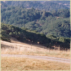
128, an insanely winding – and often nauseating – two lane
road that winds through Anderson Valley and eventually passes through
Boonville.
Here’s a more detailed description of how to get to the
Boonville Hotel:
- Step 1: get on 101 North from San Francisco
or Oakland. If you’re coming directly from the Airport,
we’ll give you Mapquest directions below. If you’re staying
in Berkeley, you’re going to get on 80 North, and then follow signs
for 580 North and the Richmond Bridge. You’ll go over the Richmond
Bridge, merge into 101 North and then stay on that for about 70 miles.
From San Francisico, you’re going to have to make your way to the
Golden Gate Bridge, cross it, and then keep following signs for 101 North.
- Step 2: get onto 128 West. After about
an hour on 101 (70 miles or so), you’ll see signs for Route 128
and Cloverdale. Take the exit for 128 West – Boonville. Make a left
at the bottom of the off-ramp, and then make a right onto 128 West. There
will be several signs for Boonville and 128, shouldn’t be hard to
miss.
- Step 3: Drive on 128 for 27 miles until you
hit Boonville. Buckle up, drive slowly, enjoy the drive, stop
if you need to: this part of the trip will take you as long as the first
part. 128 is super windy. When you see signs that suggest that you take
the next turn at 20 MPH, slow down. When you see a sign that says the
road will be windy for the next 6 miles, believe it. Local drivers know
this road like the back of their hands, so feel free to pull over (there
are many places to do this) and let them go ahead of you. We probably
do this 6-7 times each way. The town of Yorkville (population 25) has
a convenience store and a bathroom if you need a break. At some point
on 128, you will say or think, “where the hell are we going?”
Hang in there, it’ll be worth it.
- Step 4: Stop at the Boonville Hotel.
Eventually, 128 straightens out, you’ll pass the Boonville Fire
Station, you’ll pass a turn-off for 253 (to Ukiah), and then suddenly
you’ll be in the little town of Boonville. The whole town is about
4 blocks long, and when you see a sign for the Boonville Hotel on your
left, pull over, park, and come in for a fizzy drink.
For the cut and dry version of these directions, check Mapquest. Here
are the directions from Oakland
Airport and from San
Francisco Airport .
Directions to Indian Creek
If you’re staying at the Indian Creek Inn, just up the road,
here are the directions:
- Continue West on 128 (past Boonville) for 3 miles, maybe 10 minutes
the first time you do it.
- Keep your eye out for the Goldeneye Vineyard on your left. When you
see it, you’ll see a long, white fence protecting the vineyard.
- At the end of the fence, there’s a little dirt road. Turn left
on to the road, and follow it up along the edge of the vineyard. The road
forks once or twice, but just don’t go down the roads marked “Private
Property” and you’ll find yourself at the Indian Creek campgrounds
in less than a minute.
Directions to the Apple Farm
If you’re staying at the Apple Farm, you’re not to
far away either:
- Continue West on 128 (past Boonville) for 6 miles, maybe 15 minutes.
You’ll pass through the town of Philo.
- Make a left on to Philo Greenwood Road. There’s a sign and arrow
for the Apple Farm and for Hendy State Woods.
- Less than a mile down the road, you’ll see the Apple Farm on your
left. If you go over a bridge, you’ve gone too far!
- Click here for the Mapquest directions from the Boonville Hotel
